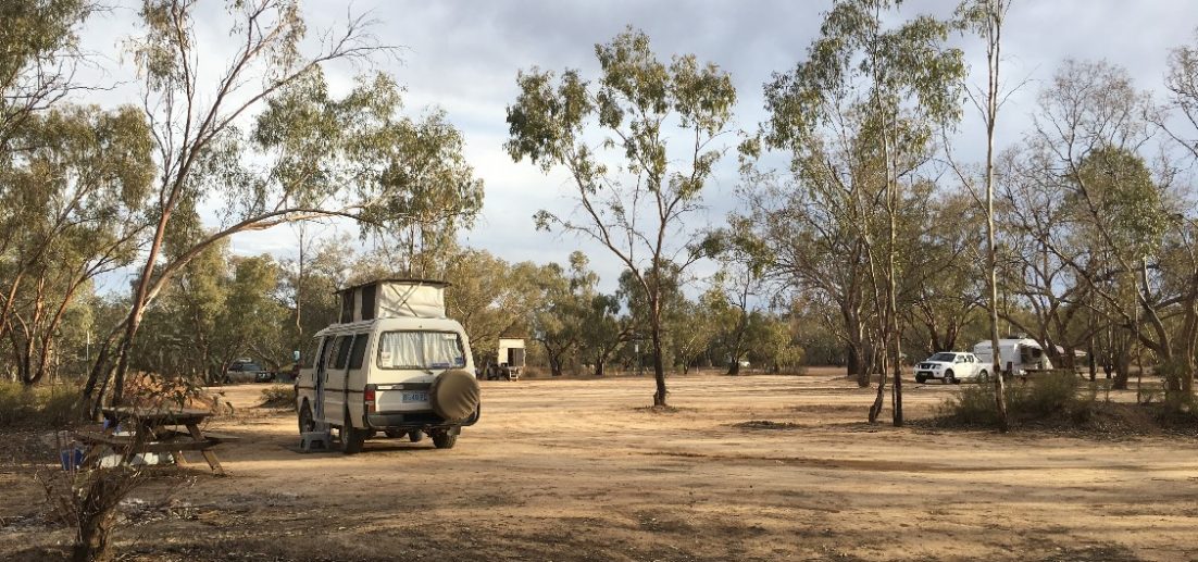
I don’t think I’ll ever get rid of the fine red dust that has made its way through every crack and crevice in my campervan, covering everything – and I mean everything – in Pilbara dust. Nothing escaped! It filtered into every cupboard, all my clothes, my bedding, my curtains, my pantry – and continues to do so every time I go over a bump. It’s hiding everywhere just waiting to dump itself on me somehow! Love the Pilbara – hate the dust!!
The road to Millstream Chichester National Park was a nightmare and the main cause of the dust invasion in my van. It was rough, corrugated, red and seemed to go on forever. Wilma and I had looked at all our maps and decided to take the road south of Karratha instead of the road from Roebourne, or the one even further north near Port Hedland. Those other roads were black top, but not ours! My normal map source doesn’t even show the road we took, but this is a great map of the Pilbara I found and I have drawn in – very badly in orange – our route.
Red Dust - and local wildlife
However, the destination made up for the journey on this occasion and we camped for 2 nights at Millstream Homestead – Miliyanha Camp. What an oasis! We were particularly interested in it because Clint, our aboriginal guide at the Burrup Peninsula was from the Yindjibarndi people and Millstream has particular significance for them. The brochure about Millstream Chichester National Park explains it better than I can, so I quote
“(this)..area is a very significant indigenous cultural site in northern Western Australia. Its cultural and mythological importance stems from thousands of years of occupation, with Millstream being the home of the mythological serpent or warlu, whose presence is still strongly felt at Nhanggangunha (Deep Reach Pool).”
As an aside, the highway leading into and out of Karratha and Karajini is called Warlu Way.
“Aside from its highly important spiritual significance, Millstream was an important campsite for inter-tribal meetings. The Fortescue River provided food and water, particularly during drier months.”
Millstream was named in 1861, and the first pastoral lease was taken up in 1865. “In its heyday the station covered more than 400,000 hectares and ran 55,000 sheep.”
Sit awhile?
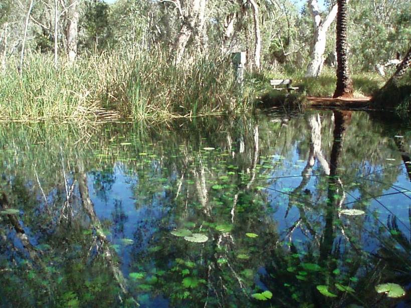
A short walk from the homestead took us to the Lily Pool that Clint, our aboriginal guide at the Burrup Peninsula, had shown us photos of. It was a place of such natural beauty and so peaceful I could have relaxed there for hours.
Millstream Lily Pool
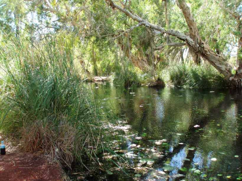
Millstream Lily Pool
The water that feeds the Millstream oasis springs from an aquifer, or natural underground reserve fed by the Fortescue River catchment, which includes run-off from the Hamersley Range. This aquifer has an estimated area of 2000 square kilometres and is believed to contain 1700 million cubic metres of water.
As we left Millstream for Karijini we took a side tour to Deep Reach Pool, mentioned above. This view is from the cliff top looking over the Millstream Palms.
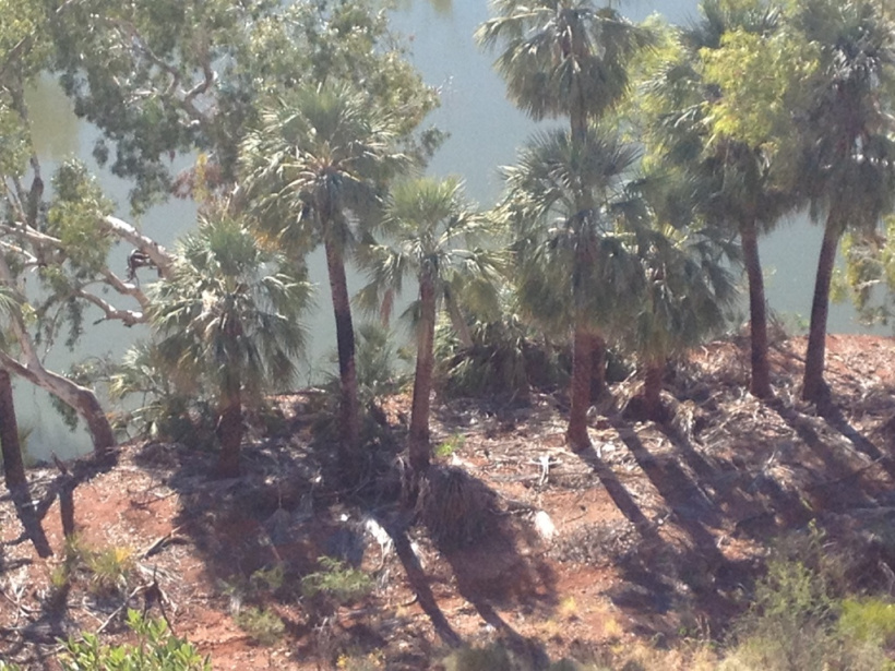
Millstream Palms at Deep Reach
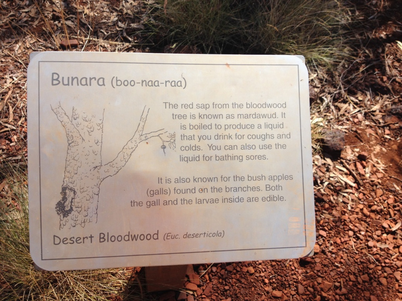
There was a pleasant cliff top walk that wound through Snappy Gums and Bloodwood Trees. Are they snappy because they’re angry do you think?? I get a bit that way myself at times!
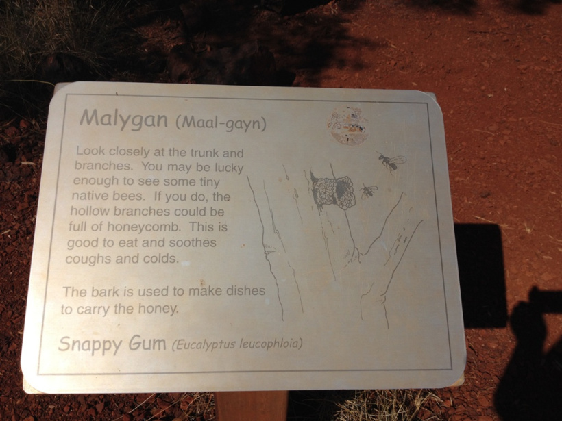
Snappy Gum
The cliff top walk also included the story of how the Rainbow Serpent created the Fortescue River - pretty gruesome story, too, a bit like some of our Fairy Tales!
Fortescue River
With some trepidation we were on our way to Karijini, knowing that we had to face that nightmare of a road again.

September 5, 2014 at 12:07 am
Sounds like you’re having a great adventure Rosemary. Looking at the route on your map, I’d say you took the northern part of the Tom Price railway line maintenance track into Millstream. August is probably the driest month up there, so red bulldust is par for the course I’m afraid. You’ve got a great treat ahead of you at Karijini. Try to allow at least 3 days, and preferably longer if you can. Some of the pools in the gorges are great for swimming. Might be a bit cool at this time of year though! If you plan to head north or south on the Great Northern Highway after Karijini, don’t forget to refuel at Newman. Fuel prices on the northern part of the highway are pretty steep, although not as bad as the Nanutarra Roadhouse between Exmouth and Onslow. If you’re heading north, you would probably enjoy staying overnight at Indee Station, about 30km south of the intersection with the North West Coastal Highway. If you’re heading south, take the time to pull into the lookout at Mt Robinson. It’s a good overnight camping place too. We enjoyed staying at Nallan Station, about 12km north of Cue; although a friend recently said that they had closed their campsite at the old shearing quarters. Cue is a historic gold mining town and it’s worth taking a walk around it. I don’t know what your plans are, but if you missed the wildflowers in the Northern Wheatbelt on your way north, it might be worth your while travelling west from Mt Magnet on the Geraldton-Mt Magnet Road to Mullewa and heading south from there. The northern wildflowers will have passed their peak by now, but there will probably still be plenty to see. There is a nice little caravan park at Yalgoo and the park manager will give you a key to the historic buildings, including the tiny chapel on the site of the old catholic boarding school. It’s one of the many churches in the Northern Wheatbelt designed and built by Monsignor John Hawes in the 1920s. The cathedral at Geraldton is also his design. If you do head towards Mullewa, I highly recommend a visit to his parish church and presbytery there. The local Tourist Office will also be able to tell you where the best wildflower displays are. When we were last in that area, there was a fantastic display of wreath flowers on the Beringarra-Pindar Road, just a few kilometres north of Pindar. Pindar is on the Geraldton-Mt Magnet Road about 30km east of Mullewa. You might also be interested in the story of the Butterabby graves about 12km south of Mullewa on the Mingenew-Mullewa Road. I would advise against free-camping near Mullewa itself unless you are in the company of others. One alternative would be the Breakaway campsite in the Coalseam Conservation Park, about 35km south of Mullewa. There are caravan parks at Mingenew, Carnamah and Perenjori and the Shire Council runs a nice little caravan park at Dalwallinu. if you are in a hurry to head back to the eastern states, an interesting alternative route would be to head east at Mount Magnet on the Mount Magnet-Sandstone Road to Leinster, then south on the Goldfields Highway to Leonora (well worth a visit, especially the nearby historic gold mining centre of Gwalia). Goongarrie Station between Menzies and Kalgoorlie has a nice camping spot. From Kalgoorlie you would head south to Norseman and thence across the Nullarbor. We prefer to stay at Fraser Range Station (about 100km east of Norseman) rather than in Norseman itself.
Best wishes, Graham & Donna
LikeLike
September 12, 2014 at 10:41 am
Absolutely fantastic Rosemary…as usual….this is without doubt the best thing (I think) you’ve ever done in your life!
LikeLike
March 25, 2021 at 1:59 pm
beutiful
LikeLike