The Snail Trail

Travelling with my home on my back and in no hurry to get anywhere

Timber Creek (MC)


4 Comments

Bats, Birds …. and Zebras?

When I left Katherine I headed west towards Kununurra –  Darwin, Litchfield and Kakadu will have to wait for another time. I  keep telling myself  “You can’t see everything” …. but …..I really want to! The problem is, the more you see the more you realize there is to see. How some people zip around the continent in a couple of months I’ll never know! They need to read my poem called ‘I Travel in the Slow Lane‘.….

My first stop on the way to the WA border was Timber Creek, where I finally caught up with Margaret.

Katherine to Kununurra
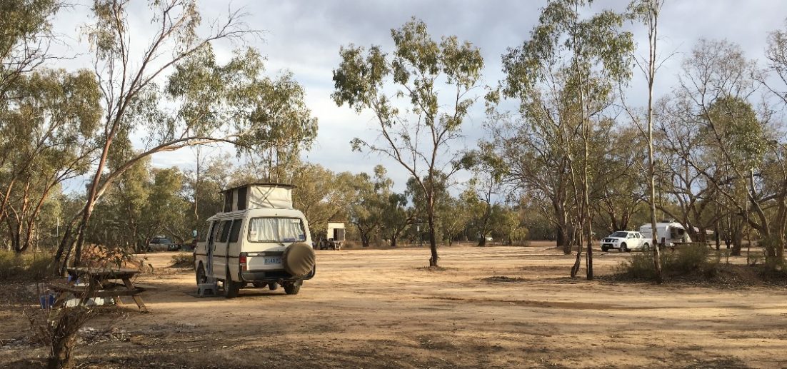
I surprised Margaret by turning up when I did as she had booked into the caravan park for the night so I went about 10kms out of town to Big Horse Creek, a great low cost camp ($3.30 a night) on the banks of the Victoria River. It was quiet and peaceful, not like Margaret’s night with screeching bats (flying foxes) around her camp.

Margaret joined me at Big Horse Creek the next day but we popped back into Timber Creek for the Family Festival which was being held. Not much to see but I loved the decorations in the trees outside their community centre.(and the scones fresh from the oven with loads of jam and cream!)

There were a couple of highlights of our stay at Big Horse Creek. The first one was when a Bowerbird displayed his bright pink comb for us – looks so out of place on such a dull coloured bird …. We have seen lots of these since around Daly Waters but these are the first that showed the pink on their necks. They are funny to watch as they are quite a big bird and they hop rather than walk. They were collecting the white pith out of the boab nuts to decorate their bowers with.

Margaret also captured some great shots of some of the other birds in the area ….

The second highlight of this stopover was catching up with Brian, whose farmhouse I had camped behind in Cudall, west of Orange NSW, about 18 months ago. He was heading east, I was heading west, and although he arrived late in the day and Margaret and I left early the following morning it was fun to fill in the gaps of the last 18 months.

Our next camp was only a few kilometres shy of the Western Australia border at the Zebra Rock Mine. It was down a very dusty, corrugated road and then through a couple of farm gates to arrive at the camping ground. The Zebra Rock is amazing and is only found in this part of the world and the Zebra Rock Mine is the only operating mine.

The age of Zebra Rock has been placed at 600 million years in the Upper Proterozoic era or Pre-Cambrian period.

The only known deposits of Zebra Rock in the world have been found near Kununurra in the East Kimberley region of Western Australia.

It was really unusual and quite beautiful

This slideshow requires JavaScript.

I had an extra night here while Sue, Margaret and Nev went off to Lake Argyle for a couple of days. It was time to cook up all my vegetables and eat all my fruit so that I had nothing to declare at the quarantine stop when I crossed the border into Western Australia on my way to Kununurra.

WA BorderI feel like I’m home!

Finke River, Northern Territory


1 Comment

Pastors, Prams and Palm Valley

We took the opportunity to book a 4wd tour to Palm Valley while in Alice Springs and go to a place our motorhomes wouldn’t be capable of taking us. On the way to Palm Valley we travelled alongside the amazing West MacDonnell Ranges to Hermannsburg, the historical site of an old Lutheran mission. I know I posted photos of the West Macs in my last post but here’s a selection from the trip to Hermannsburg. As you can see it was a very overcast day and it looked like a storm was threatening although all we got was a misty low cloud hanging over us at its worst. But the sky was amazing…

On the way to Hermannsburg we stopped at an Albert Namatjira Memorial. Namatjira was raised at Hermannsburg and the place is credited with encouraging his ability.

Then it was on to Hermannsburg.

Hermannsburg Mission was managed by the Lutherans continuously from 1877 to 1982. The structures and landscaping of the Hermannsburg Historic Precinct reflect the changing phases of missionary and government policy towards Aboriginal people over this period.

The mission functioned as a refuge for Aboriginal people during the violent frontier conflict that was a feature of early pastoral settlement in central Australia. The Lutheran missionaries helped mediate conflict between pastoralists, the police and Aboriginal people, and spoke out publicly about the violence, sparking heated national debate.

The I have been told that the first Lutheran minister took 20 months to walk from Adelaide with his companions to establish the mission at Hermannsburg – what a trek that must have been, with no roads and not knowing where there would be water in this hot dry inland. Strehlow was another of their Lutheran pastors and it is interesting to read about how he recognised the aboriginal culture, quite unusual as most white people wanted to erase it from the communities in their quest to make the natives conform to ‘white-man’s’ thinking.  It is now a small aboriginal community and relies on volunteers to keep the historic precinct open to the public. In this slide show you will see Karin, one of our fellow Solo travellers, who is volunteering out there at the moment.

This slideshow requires JavaScript.

We then had the opportunity to do the first of three walks, this one a short climb up one of the tracks to what is known as Lizard Rock (Kalarranga Lookout). I looked at the climb and then decided to have a go at it – climbing hills is not my favourite pastime – but the views from the top were worth the effort.

Our next walk was through the Cycad Gorge – amazing lushness in this arid land.

Cycads are plants of great antiquity, being the oldest living representatives of the Gymnosperms – the first seed-bearing plants. They are the descendants of the Bennettitales (cycad-ferns) which flourished in the Mesozoic age and probably dominated the vegetation of the world some 200 million years ago.

Jim Oliff

Our bus dropped us off at one end of this short walk and picked us up at the other end. Once again, a beautiful environment and so unexpected in this area. Our driver was telling us that the rocks are basically sandstone and the water seeps through them over a period of time and becomes underground water that provides a permanent water source that these plants, and the palms in Palm Valley, survive on.

The main walk of the day was a loop through Palm Valley in the Finke Gorge National Park.

The track to Palm Valley is still only accessible with a four-wheel drive vehicle. It departs from the town of Hermannsburg and travels south, following the usually dry bed of the Finke River. Palm Creek flows into the Finke River from the west about 15 km (by track) south of Hermannsburg. The track follows the creek to Palm Valley about 5 km west of the Finke River.                                                            (source Wikipedia)

This slideshow requires JavaScript.

Only 2.5kms it was a little more testing than the Lizard Rock walk as we clambered up to the rim of the valley and then made our way back to the bus. It was quite spectacular (I’m sure I’m using this word far too often!)  It truly was like an oasis in the desert. The palm trees that grow here are Red Cabbage Palms.

Our bus driver, Phil, was full of information and enthusiastic about the area – and loved the 4 wheel driving through deep sand and over rocks. After leaving Hermannsburg we were basically travelling along the dry Finke River bed and then Palm Creek so it was sandy in spots, rocky in others, but totally picturesque the whole way.

What a fantastic day! We left home at 7am and arrived back at 6pm. Many thanks to my travelling buddy Margaret Cook for sharing her photos with me – and therefore with you. I hope I’ve identified Margaret’s photos with (MC).

Our last photo stop was at Pram Creek….I wonder how it got its name?

Finke River, Northern Territory

Pram Creek

Standley Chasm, Northern Territory


2 Comments

Chasms, Cliffs and Caterpillar Dreaming

In the Arrernte Aboriginal people’s Dreamtime story, this region was created by giant caterpillars. These creatures became the stunning ridges of the East and West Macdonnell Ranges that shelter the town of Alice Springs.   from  Do the NT

I love the Dreamtime stories of the traditional owners in the different areas of Australia that I have visited and the Arrernte people around Alice Springs tell of giant caterpillars that formed the MacDonnell Ranges. Today we drove out to Standley Chasm and I saw those caterpillars form the ridges of the West Macs…what do you think?

West MacDonnell Ranges, Northern Territory

West MacDonnell Ranges

You can listen to one of the traditional owners tell the story of the caterpillars here. The story you want is Yipirinya Dreaming. This web site has some wonderful photos and information about the West MacDonnell Ranges and is well worth investigating.

I also found a wonderful site where you can read the story of the encounter of the three caterpillars. There are other traditional stories on this site too, and recommendations of dreamtime story books for children.

Margaret has captured these ‘caterpillar’ ridges beautifully…

Your view of the West MacDonnells changes with every bend of the road but each one is beautiful in its own way.

Today we drove out along the line of the West Macs to visit Standley Chasm. This is named after a teacher, Ida Standley, who was the first teacher at the Jay Creek Settlement in 1929, and the first white woman to visit the chasm which has been given her name. Stunning is the only word to describe it!

Standley Chasm, Northern Territory

Standley Chasm

Here’s a selection of my favourite photos of the walk into the chasm and then some different views of the chasm itself…Margaret took the photos in this slide show (thought I’d show you the best ones first)!

This slideshow requires JavaScript.

….and I took these….

This slideshow requires JavaScript.

What do you think? Isn’t it the most spectacular place?

Alice Springs Desert Park


2 Comments

Alice, Alice, Where the Hell is Alice!

We’re not looking for a person here – we’re in Alice Springs and as Australians do with most things, it’s been given a nickname – “The Alice”. I’m in the Red Centre of Australia – the earth is red, the ranges are red, and if you stay out in the sun too long you’ll go red, too!

Alice Springs

The Red Centre

There’s a lot to see and do in Alice Springs, situated as it is in between the East and West MacDonnell Ranges and on the highway between Adelaide and Darwin. Beautiful rugged escarpments, wonderful gorges and historical settlements have kept me busy for the few days I’ve been here. I’ll try and give you a brief overview of some of the attractions….wish I  could go to everything, but time and money have forced me to be selective!

The Alice Springs Telegraph Station

The Alice Springs Telegraph Station Historical Reserve marks the original site of the first European settlement in Alice Springs. Established in 1871 to relay messages between Darwin and Adelaide and linking with an underwater cable network to London – England. Establishing the first real communication between Australia and England.

This slideshow requires JavaScript.

Alice Springs Desert Park

If you ever go to Alice Springs make sure you visit the Desert Park! And set aside a full day or do it over a couple of days. There is so much to see and so many informative sessions they run that it’s impossible to do it all in one day. As we were leaving we mentioned that it was a shame they didn’t offer a 2 day pass (or 3 days as they do at Uluru) and it was only then we were told that for an extra $5 we could have had that option. The program is intense, with demonstrations of bush survival skills, free flying birds, the nocturnal house and so much more. I’ve tried to organise my photos into sections and this first slideshow is some of the landscape in the park.

This slideshow requires JavaScript.

The walk through aviaries were wonderful and gave me the opportunity to see close-up some of the birds I’ve longed to see. Margaret’s bird photos are fantastic and I’ll try and identify the birds for you in the slide show.

This slideshow requires JavaScript.

And the dingos were a highlight of the animals and reptiles in the park.

This slideshow requires JavaScript.

We went to three different presentations, the first conducted by Anne about Bush Survival Skills. She was so informative and with such a great sense of humour the time just flew.

Anne also took us through the Nocturnal House where we saw a bilby and ghost bats, but the highlight at the end of the day was the free flying birds. How they come in out of the wild on cue is amazing ….  well, ok, the ranger had treats for them so they were bribed but they all appeared in turn at just the right time. Hard to photograph as they were on the wing most of the time but Margaret managed to get a few thank goodness.

The Desert Park was a great experience, so varied, wonderful staff and very informative. I went with Margaret, Pam and Lorraine, all fellow solo travellers and every single one of us enjoyed it. If you’re in Alice Springs, don’t miss it!

My next Alice Springs adventure is to head out to some of the gorges in the West and East MacDonnell Ranges with a visit to Hermannsburg and Palm Valley. I’ll tell you all about next time!

Sounds of Silence, Uluru, NT


1 Comment

Sounds of Silence – Dining Under the Stars

Well that’s a birthday celebration I will never forget! A very special dinner under the stars as the sun set on Uluru. The candles were lit, the champagne poured, the tables set with crisp white cloths, the food was magnificent and the stage was set with the didgeridoo playing in the background……

This slideshow requires JavaScript.

I wonder how I can top this next year?

Uluru Northern Territory


1 Comment

Uluru and Kata Tjuta – The Heart of Australia

It is amazing to be here and I am in awe of the magnificent natural rock formations of Uluru and Kata Tjuta.

Uluru Northern Territory

There it is!

Some quick Uluru and Kata Tjuta facts:

  • Uluru is 348 metres above ground and 9.4 kilometres around the base.(5.8 miles)
  • Kata Tjuta is 546 metres above the ground and consists of 36 domes spread over an area of more than 20 kilometres
  • Kata Tjuta is a Pitjantjatjara Aboriginal tribe word meaning ‘many heads’.

These are intensely spiritual places for indigineous Australians, the traditional land owners, and many white Australians also feel the spirit of these stunning landmarks.

Traditional religious philosophy, Tjukurpa, provides an interpretation of the present landscape, flora, fauna and natural phenomena in terms of the journeys and activities of ancestral beings and consequently binds the people socially, spiritually and historically to the land.

Quote from http://whc.unesco.org/en/list/447

The Cultural Heritage Centre tells the story of how some of the features of the rock are formed and I love these stories that form the basis of the culture and law of the Anangu people. This site I found has the most comprehensive rendition of the stories that are depicted in the Cultural Centre.

Aboriginal Beliefs Connected With Uluru

And this YouTube clip has Barbara Tjikatu, a tradtional owner of the Uluru-Kata Tjuta region, telling of the Creation Story and how some of the features of the rock were formed.

Here’s another couple of links that give some great information

About Uluru and Kata Tjuta

Uluru

Fellow Solo traveller Margaret and I camped at Ayres Rock Resort Campground and drove the 20 or so Kilometres to Uluru (formerly known as Ayres Rock) and then a further 50 to Kata Tjuta. Between us we took masses of photos and I hope I’ve chosen some of the best to show you here. Margaret’s have been identified with (MC).

As you move around this massive monolith there are so many different features and I hope we have captured some of the better ones. From a distance you can’t see the hidden crevices and fissures that make the variations so interesting.

NOTE: Our apologies to the traditional owners if we have photographed culturally sensitive areas of Uluru and upon request I will certainly remove any photos that may unintentionally offend.

This slideshow requires JavaScript.

From Uluru we drove about 50kms to Kata Tjuta (formerly known as The Olgas). Here is some great information:

Kata Tjuta

There are 36 domes that make up Kata Tjuta and they cover about 20 kilometres. Kata Tjuta is a Pitjantjatjara Aboriginal tribe word meaning ‘many heads’ and you can certainly see how it got this name. I never realized these domes were so huge,

Once again, these photos are a combination of Margaret’s and mine and I’ll let them do the talking …

This slideshow requires JavaScript.

Our Uluru experience is far from over! Today we are attending some of the activities the resort offers such as the Bush Tucker Garden, Indigenous Dancers and Didgeridoo Playing and to cap it all off tonight I am celebrating my birthday at the Sounds of Silence dinner watching sunset over The Rock!

Life’s Good!